サイクリングで使える無料アプリ15選!走行距離や消費カロリーの記録も

サイクリングで使える無料アプリ15選!走行距離や消費カロリーの記録も

今回はサイクリングに使える無料アプリを厳選15種紹介します。走行距離や消費カロリーの表示はもちろん、サイクルコンピューター代わりにもなるログを記録できるアプリもあります。また、サイクリングのルート検索や役立つ情報、合間に楽しめるゲームなども紹介します。

記事の目次

  1. 1.サイクリングで使える無料アプリの種類
  2. 2.サイクリングで使える無料アプリ【マップ・ルート検索アプリ】5選
  3. 3.サイクリングで使える無料アプリ【データ記録可能アプリ】5選
  4. 4.サイクリングで使える無料アプリ【その他人気アプリ】5選
  5. 5.無料アプリを有効活用してサイクリングを充実させよう!

サイクリングで使える無料アプリの種類

一口にサイクリングに使えるアプリといっても、実にさまざまな種類のアプリがありますので、自分の目的、用途に合ったものを選ぶ必要があります。今回は下記3種類の無料アプリの中から厳選した15個のアプリを紹介しますので、参考にしてみてください。

今回紹介するサイクリング無料アプリの種類

  • ルート検索や地図の閲覧ができる【マップ・ルート検索アプリ】
  • 走行距離や所要時間、消費カロリーなど、ログを記録できる【データ記録可能アプリ】
  • サイクリングに役立つ情報やゲームなど【その他人気アプリ】

サイクリングで使える無料アプリ【マップ・ルート検索アプリ】5選

https://products.navitime.co.jp/service/bicycle/android_sp.html

ここではまず、サイクリングやツーリングに欠かせない道のナビとしても使える、マップ・ルート検索の無料アプリを5つ紹介します。

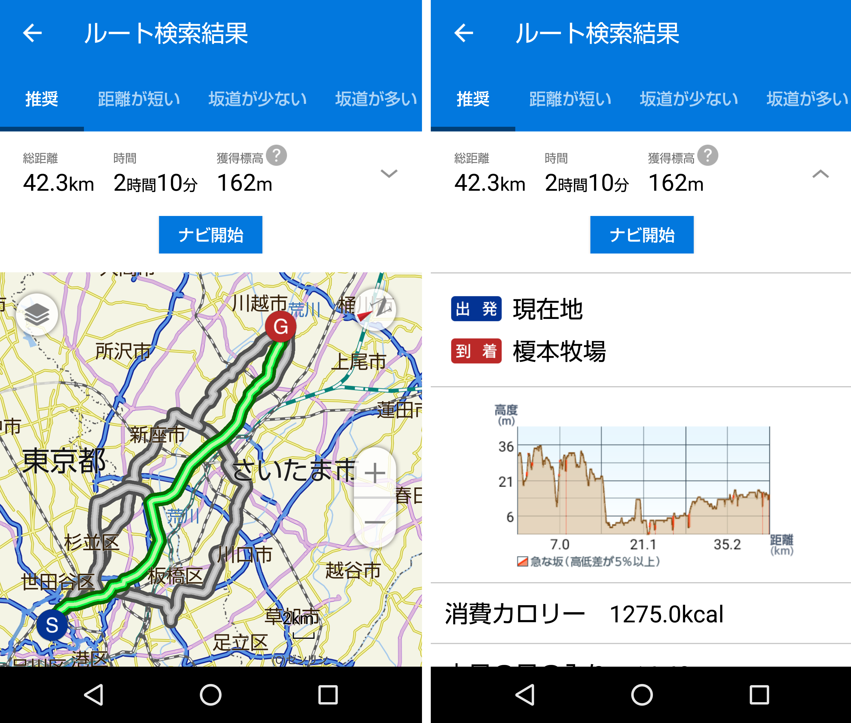
サイクリングで使える無料アプリ【マップ・ルート検索アプリ】①自転車NAVITIME

出典:amazon

自転車に特化したルート検索、地図アプリです。無料コースではGPS機能によりアプリがおすすめするルートが提示され、走行距離のほかに、道の高低差や獲得標高、消費カロリーの目安まで確認できます。また、月間10kmまではナビ機能が無料、スマートフォンの節電に役立つ音声のみのナビも可能です。そして、マップ上でコンビニやカフェなどのスポット検索もできますので、サイクリング、ツーリングの楽しみがさらに広がります。

有料コースはサービスが充実!

出典:自転車NAVITIME

有料コースではさらにGPS機能を稼働し、坂道が少ない、坂道が多い、裏道優先など、計6種類のルート検索が可能なため、比較しながら最適な道を選択できます。また、ルートや走行距離、消費カロリーなどを記録しておける、ログ機能も使用可能ですので、特にロードバイクなど長距離を走る場合におすすめです。

自転車NAVITIME をApp Storeで
‎「自転車NAVITIME - 自転車ナビ&走行距離&速度」のレビューをチェック、カスタマー評価を比較、スクリーンショットと詳細情報を確認することができます。「自転車NAVITIME - 自転車ナビ&走行距離&速度」をダウンロードしてiPhone、iPad、iPod touchでお楽しみください。
自転車NAVITIME をGoogle Playで
Bicycle NAVITIME is a cycling app that can be used all across Japan. It has both English and Chinese (Traditional and Simplified) language support. ▼Features with multi-language support [Spot search] Search for spots by keywords or categories. [Cycling station search] Search for spots (cycling stations) where cycling racks or tire pumps are available. Availability of cycling racks Type of air pump installed on-site (Presta/Schrader/Dunlop valve) Availability of tools Availability of public restrooms [Route search] Free users are able to use recommended routes. Sign up for the premium course to receive access to search for seven types of routes: Recommended (based on distance, time, elevation, etc.) Short distance Few hills Hilly Prioritize main roads Prioritize back roads Prioritize cycling roads (take routes that preferentially use nearby cycling roads) [Transit point specification] (Premium users only) Search for routes with specified transit points. [Voice navigation] *Voice support only available in English. An English voice will sound even when set to Chinese. Free users: Available to use once per month (no distance limit) Premium users: No restriction on distance or number of uses [Energy-saving mode] Navigation continues even when the screen is turned off during voice navigation. This reduces battery consumption. [Elevation graph] Elevation can be seen on a graph, so users can get an idea of the highs and lows of the route. *Voice support only available in English. An English voice will sound even when set to Chinese. ▼Premium course Fee: Monthly billing (automatic renewal) ¥300 (tax included) [Payment method] In-app Purchase ▼Precautions Please ride in accordance with traffic laws at all times. If unable to scroll the map, please check the following setting: From the device’s “Settings,” tap “Developer Options” On the next page, set “Force GPU rendering” to OFF. ▼Confirmed functionality for the following models Devices using Android 4.1 or higher *Functionality is not guaranteed for WiFi-only devices, as operation may not be stable depending on the user’s communication environment. *For devices not equipped with a GPS, the app will not be able to accurately locate the user’s position, so certain features such as the user’s current location map and navigation will be unavailable.

サイクリングで使える無料アプリ【マップ・ルート検索アプリ】②トラベルコ マップ

出典:トラベルコ

300以上登録されている国と島のマップを事前にダウンロードしておけば、オフラインでも閲覧できる地図アプリです。自転車ルートの検索はできませんが、徒歩、自動車によるルート検索ができ、ナビもしてくれます。また、トラベルコらしくホテルやレストラン、観光スポットなども、世界100万件以上の情報が登録されています。

‎トラベルコ マップをApp Storeで
‎「トラベルコ マップ/海外・国内で使えるオフライン地図」のレビューをチェック、カスタマー評価を比較、スクリーンショットと詳細情報を確認することができます。「トラベルコ マップ/海外・国内で使えるオフライン地図」をダウンロードしてiPhone、iPad、iPod touchでお楽しみください。
トラベルコ マップをGoogle Playで
The travel comparison website Travelko is now introducing a new offline map that you can use for free even when not connected to the internet! Even on a trip and with no internet access, you can still use the map as long as you had downloaded it in advance! -Even offline, you have access to all data from OpenStreetMap in which people from all over the world upload new places and routes every day. -“Travelko’s favorites” include many reviews about tourist attractions, shopping etc. for 12 cities in Japan and information restaurants all over the world! -You can bookmark and edit new spots that are not on the map yet! 【Best of the app】 -Not only do you have access to all the data from OpenStreetMap but you can also access Travelko latest information about 138 cities worldwide. -Information about risky countries and advice from locals are also available for some places. -You can bookmark new spots and any kind of places that are not on the map yet! 【Functions】 1.Map browser Free download of maps covering over 300 countries and islands. After downloading the map, you can use it for free with airplane mode so you will never receive any alert or message anywhere in the world. 2.Spot search As you have access to all data from OpenStreetMap, you can search from more than a million restaurants, tourist attractions, Wi-Fi spots etc. worldwide! 3.Route search You can search how to go to any place. Pedestrian and cyclist’s roads are available as well as a navigation system. 4.Bookmark places You can bookmark places that you want to. After bookmarking them, you can label them. You can also bookmark places that are not on the map already and add them to the map. 5.Travelko’s favorites Learn new information about 12 popular cities in Japan, their tourist spots and where you should go shopping directly from experienced guides. You can also check much information about restaurants worldwide! 6.Share spot information/Read spot information You can read and bookmark spot information that was created under kml/kmz in other apps. 【Best for people who】 -Want to use their map even when they have no internet access on vacation -Can never find their current position on a regular map -Want to check and find places they have previously searched and bookmarked -Want to find exciting attractions while on vacation -Want to use their GPS to their destination while on vacation 【Caution】 -The map data comes from OpenStreetMap (https://www.openstreetmap.org/). If you notice any old or inaccurate information, please let us know by sending a message to 「Enquiry」in the tool bar inside the app. -If you notice any old or inaccurate information in Travelko’s favorites, please let us know by sending a message to 「Enquiry」in the tool bar inside the app. -No message or alert will be sent to you when using the map but they are necessary when downloading the map. -The map data is high usage so we would recommend that you download it using Wi-Fi. -Please be aware that GPS idle may increase battery drain. -Your current location cannot be retrieved on devices without a GPS. Please use a device with a built-in GPS.

サイクリングで使える無料アプリ【マップ・ルート検索アプリ】③Google マップ

Photo bydeepanker70

Googleマップはスマホやタブレットにデフォルトでインストールされていることが多い、最も有名な地図アプリの1つです。日本版に以前から切望されていた自転車ルートが加わったため、サイクリング、ツーリング中のスマートフォンでのナビがより使いやすくなり、さらにおすすめ度が増しました。

GPSをフル活用!

Photo byPhotoMIX-Company

とにかくGPSの機能をフル活用し、道路の交通量や交通機関の運行状況なども加味してルート検索してくれます。また、住所を始め、店名、ビル名、ざっくりした地域名でも検索できますので、目的地の詳しい情報が無くても心配ありません。

Google マップをApp Storeで
‎「Google マップ - 乗換案内 & グルメ」のレビューをチェック、カスタマー評価を比較、スクリーンショットと詳細情報を確認することができます。「Google マップ - 乗換案内 & グルメ」をダウンロードしてiPhone、iPad、iPod touchでお楽しみください。
Google マップをGoogle Playで
Navigate your world faster and easier with Google Maps. Over 220 countries and territories mapped and hundreds of millions of businesses and places on the map. Get real-time GPS navigation, traffic, and transit info, and explore local neighborhoods by knowing where to eat, drink and go - no matter what part of the world you’re in. Get there faster with real-time updates • Beat traffic with real-time ETAs and traffic conditions • Catch your bus, train, or ride-share with real-time transit info • Save time with automatic rerouting based on live traffic, incidents, and road closures Discover places and explore like a local • Discover local restaurant, events, and activities that matter to you • Know what’s trending and new places that are opening in the areas you care about • Decide more confidently with “Your match,” a number on how likely you are to like a place • Group planning made easy. Share a shortlist of options and vote in real-time • Create lists of your favorite places and share with friends • Follow must-try places recommended by local experts, Google, and publishers • Review places you’ve visited. Add photos, missing roads and places. More experiences on Google Maps • Offline maps to search and navigate without an internet connection • Street View and indoor imagery for restaurants, shops, museums and more • Indoor maps to quickly find your way inside big places like airports, malls and stadiums * Some features not available in all countries * Navigation isn't intended to be used by oversized or emergency vehicles

サイクリングで使える無料アプリ【マップ・ルート検索アプリ】④ここ地図(by NAVITIME)

出典:NAVITIME

地図アプリでナビを見ている時に、自分の向かっている方向が分からなくなった経験はありませんか?このアプリは走行距離と方向を指し示すマーカー機能があり、ランドマーク的な建物が3Dで表示されるため、現在地が分かりやすくなっています。特にロードバイクはあっという間に距離を進んでしまうため、このアプリがおすすめです。

ここ地図をApp Storeで
‎「ここ地図 - 自転車ルートにも対応したシンプルな地図アプリ」のレビューをチェック、カスタマー評価を比較、スクリーンショットと詳細情報を確認することができます。「ここ地図 - 自転車ルートにも対応したシンプルな地図アプリ」をダウンロードしてiPhone、iPad、iPod touchでお楽しみください。
ここ地図をGoogle Playで
できること ・今いる場所を確認  ランドマークや目印がわかりやすい地図で、今いる場所をすぐに解決!   今見ている向きに地図が自動で回転するモードもあります ・お店を探す  カフェや美容院、駐車場など今欲しい場所をすぐに検索!  「電源あり」「離乳食あり」などみんながつけた便利なタグで迷わず選べます ・行き方を調べる  行きたい場所までの「歩き」「自転車」「車」「電車」それぞれの時間と道順を表示! ★すべて無料で提供中★ ※更に便利に使える機能を開発中です。ご意見などお待ちしております!

サイクリングで使える無料アプリ【マップ・ルート検索アプリ】⑤ルータン

膨大なルートデータが収録されているため、キーワードを入れるだけで数多くのルート候補を表示してくれます。ルートの比較ができる上に、GPSログの保存機能もあります。また、地図も地形図や航空写真などが見られるため、ルート作成にイメージがわきやすい優れものです。

ルータンをApp Storeで
‎「ルータン(ルート探索!)」のレビューをチェック、カスタマー評価を比較、スクリーンショットと詳細情報を確認することができます。「ルータン(ルート探索!)」をダウンロードしてiPhone、iPad、iPod touchでお楽しみください。

サイクリングで使える無料アプリ【データ記録可能アプリ】5選

ここではサイクリングの走行距離や消費カロリーなど、ログを記録しておける無料アプリを5つ紹介します。サイクルコンピューターの導入を考えている方は、まず無料アプリから試されることをおすすめします。

サイクリングで使える無料アプリ【データ記録可能アプリ】①Strava(ストラバ)

出典:ストラバ

影響が大きい機能が有料化(サブスクリプション)となり物議をかもしたストラバですが、ほかの無料アプリと比較しても全くそん色ないほど、無料の機能も充実しています。走行距離、時間、消費カロリー、速度などのログが記録できます。また、ストラバに登録している世界中のユーザーと写真で道路状況や風景などの情報が共有できますので、サイクリングルートの作成に役立ちます。

有料(サブスクリプション)機能のおすすめは【ルート作成】

出典:ストラバ公式ホームページ

ストラバの有料サービスの機能で特におすすめなのが、独自のサイクリングルートが作れるルート作成機能です。ほかのアプリにも作成機能はありますが、詳細なマップデータや、ロードバイクなどの自転車乗りに便利な機能など、その利便性はどのアプリと比較してもトップレベルです。

StravaをApp Storeで
‎「Strava トレーニング:ランニング&サイクリング」のレビューをチェック、カスタマー評価を比較、スクリーンショットと詳細情報を確認することができます。「Strava トレーニング:ランニング&サイクリング」をダウンロードしてiPhone、iPad、iPod touchでお楽しみください。
StravaをGoogle Playで
Track your fitness with Strava activity tracker. Record routes, map your favorite bike trail or run & analyze your training with all the stats – for free! Marathon training or simply love going for a bike ride? Turn your phone into a sophisticated cycle or running tracker with Strava. Try out a new trail with Strava distance tracker and mile counter or even track running speed. Join millions of active people and reach your goals! Fitness Training with Strava Activity Tracker: 3 Ways to Train Smarter 1. Record routes, track running & analyze: Track distance, swim pace, cycle speed, elevation gained & calories burned 2. Map your route: Mix up your run, swim or ride with the world’s largest trail network 3. Training challenges: Push yourself with monthly Challenges & compete with others DISTANCE TRACKER & MILE COUNTER • Track running, cycling and swimming: Compare your performance over time • Track distance, pace, speed, elevation gained and calories burned on every run • Mile counter: Use your Android device or pretty much every GPS device out there CONNECT & SHARE • Record routes on your Strava feed so friends & followers can comment & share their own progress • Your cycle route is the best? Share the route map & photos of your latest bike ride • Join Clubs of brands, teams and friends for activities and growing communities STRAVA SUBSCRIPTION • Set your fitness goals and get customizable training plans. Use the distance tracker and set your own time or segment goals • Get live feedback to help you train safer & perform better RUNNING TRACKER and TRAINING • Marathon training hit a plateau? Track distance and boost your performance with running tracker Strava and access tailored plans with Premium • Turn your device into a personal coach for triathlon or marathon training It doesn’t stop at running and cycling, you can use Strava activity tracker for a whole range of sports: • Swim • Alpine Ski • Hike • Crossfit • Kayak • Rock Climb • Surf • Yoga • Indoor running • Indoor cycling • Gym workouts ...and many more! NOTE ON GPS SUPPORT: Strava depends on GPS for recording activities. In some devices, the GPS does not work properly and Strava will not record effectively. If your Strava recordings show poor location estimation behavior, please try to update the operating system to the most recent version. There are some devices which have consistently poor performance with no known remedies. On these devices, we restrict installation of Strava, for example the Samsung Galaxy Ace 3 and the Galaxy Express 2. See our support site for more information: https://strava.zendesk.com/entries/27141334-Does-Strava-4-x-run-on-my-Android-device

サイクリングで使える無料アプリ【データ記録可能アプリ】②BikeComputer

出典:BikeComputer

BikeComputerは走行距離や消費カロリーに加え、速度まで記録できます。また、ルートの高低差をグラフで表示してくれますし、ログには獲得標高を残すこともできますので、ロードバイクでのトレーニングにも役立ちます。なおiPhoneやipadでは有料アプリの「BikeComputer Pro」になります。

BikeComputerをGoogle Playで
BikeComputer accompanies you on your bike ride with freely available offline maps - worldwide. Based on the maps you can always orientate yourself, even in the wild - without data connection. • Load offline maps for your desired region directly from the app • Follow your trip on the map and see distance, speed and all other relevant data • Plan your next trip by setting points on the map, BikeComputer calculates the track and the distance • No need to login or register • Share a session on Facebook or upload it to Strava or other workout managements • Show an elevation profile for the planned route • Set your home on the map and experience always the current (beeline) distance to it • Move waypoints of a created route using drag'n'drop and discover new trails or unknown roads that you've always wanted to try ...
‎BikeComputer ProをApp Storeで
‎Lies Rezensionen, vergleiche Kundenbewertungen, sieh dir Screenshots an und erfahre mehr über BikeComputer Pro. Lade BikeComputer Pro und genieße die App auf deinem iPhone, iPad und iPod touch.

サイクリングで使える無料アプリ【データ記録可能アプリ】③Cyclemeter

CyclemeterはGPSを使用したサイクリングのログ記録に特化したアプリのため、走行距離や消費カロリー、走行タイムに加え、速度や高度、心拍数などの細かいデータまでまとめて登録できます。また、カレンダーでログを確認できますので、ロードバイクのトレーニングにも最適です。

Siriとの連携機能

Photo by Sean MacEntee

iPhoneであればSiriとの連携機能で、スピードや心拍数を音声でリアルタイムに教えてくれます。ロードバイクなどは、走行中にスマホに視線を送るその一瞬がトラブルに繋がることもあるため、ぜひ使いたい機能です。

Cyclemeter GPSサイクリングをApp Storeで
‎「Cyclemeter GPSサイクリング、自転車、ランニング」のレビューをチェック、カスタマー評価を比較、スクリーンショットと詳細情報を確認することができます。「Cyclemeter GPSサイクリング、自転車、ランニング」をダウンロードしてiPhone、iPad、iPod touchでお楽しみください。
Cyclemeter GPSサイクリングをGoogle Playで
Cyclemeter is the most advanced application for cyclists, mountain bikers, and runners ever designed for a mobile device. Built from the ground up for Android, it makes your phone a powerful fitness computer — with maps, graphs, splits, intervals, laps, announcements, zones, training plans and more. Experience core features and dependability for free, then upgrade to Elite to add advanced features. Android Powered • Records an unlimited number of workouts — years of workouts only take up the space of a few songs. • No website login required. • Swipe across the stopwatch to see pages of stats, maps, and graphs - completely configurable. • View your workouts on a calendar, and by routes and activities. • View bar and pie charts summarizing all your workouts. Track • Exclude stopped time with automatic stop detection. • View terrain and traffic maps with Google Maps. • Record heart rate, bike speed, bike cadence, and bike power with sensors. • Automatically record the weather. Train • Supports cycling, running, walking, skating, skiing, and many other activities. • Keep on track with extremely configurable interval training, zones, and targets. • Set up repeating intervals, pyramid intervals, or tempo workouts. • Hear announcements that keep you in the zone. • Analyze your split, interval, and zone performance. Hear • Select from more than 120 configurable announcements including distance, time, speed, elevation, and heart rate. • Hear stats automatically at time or distance intervals, or on-demand with your earphone remote. • Listen to comments from friends and followers on Facebook, Twitter, and dailymile. Race • Compete against your previous workouts along a route. • See your virtual competition on a map and in graphs. Plan • Includes 5K, 10, half, and marathon running plans. • Design your own training plans. Analyze Online - See abvio.com/explorer • View the Workout Explorer on your computer or on your phone. • Share by email, Twitter, Facebook, Strava, MyFitnessPal or dailymile. • View within the app on any Info page for a workout. • View your graph, splits, intervals, zones, and more. • Select a zone to see your map path drawn with zone colors. Share • Use email, Facebook, Twitter, Strava, MyFitnessPal and dailymile to share your workouts online. • Automatically keep family and friends notified of your location and progress. • Hear replies from family, coaches, and friends spoken using text-to-speech. Import/Export • Import by tapping on a GPX, TCX, FIT or KML link or file in mail or browsers. • Export detailed CSV, GPX, TCX, FIT or KML files for use in maps, graphs, and social fitness sites.

サイクリングで使える無料アプリ【データ記録可能アプリ】④Map My Ride by Under Armour

https://www.mapmyride.com/app

Map My Ride by Under ArmourはGPSを使用し、走行距離や高低差など様々なデータが残せるアプリです。消費カロリーも計算してくれますし、体重も記録しておけますので、ダイエットにも便利です。また、ペースや心拍数などが分かりやすく図表で示されますので、ロードバイクなどで運動として自転車に乗る方に特におすすめです。

Map My Ride by Under ArmourをApp Storeで
‎「Map My Ride by Under Armour」のレビューをチェック、カスタマー評価を比較、スクリーンショットと詳細情報を確認することができます。「Map My Ride by Under Armour」をダウンロードしてiPhone、iPad、iPod touchでお楽しみください。
Map My Ride by Under ArmourをGoogle Playで
Whether you're just starting your fitness journey or are a seasoned runner, this app has what you need to stay on track and motivated to hit your goals. Get customizable Training Plans, personalized coaching tips to make running feel easier, and an inspiring community of over 60 million athletes all supporting your shared commitment to health and fitness. STAY HEALTHY AT HOME Stay active, no matter where you are, with these free Healthy at Home resources designed for at-home fitness: - Workout Routine – Mix it up with a collection of workouts designed by UA Performance Specialists that require minimal equipment. - Training Plan – Train smarter with a custom running plan fit for your exact running level and goals. - Healthy At Home Challenge – Even though we may not be physically together, we all have the same goal: to stay healthy and to keep others healthy, too. Join the Healthy at Home challenge and log 12 workouts in 30 days! Under Armour will donate up to $1 million to support Good Sports' efforts in ensuring youth sports leagues have necessary equipment. CONNECT WITH APPS AND WEARABLES - HOVR™ Infinite named one of the Best Wearable Tech of 2019 by Outside Magazine - Get Under Armour connected shoes and get more - advanced running metrics like stride length, foot strike angle, and ground contact time, - running form coaching to improve your run - 1-year of free premium - Sync with the latest apps and most wearables: Google Fit, Android Wear, Garmin, Fitbit, Suunto, etc. - Get visual, haptic, and audio progress updates in real-time - import data to further analyze your workouts - Take control of nutrition by connecting with MyFitnessPal for a comprehensive look at your calorie intake and burn. TRACK AND MAP YOUR WORKOUTS - Largest selection of activities (over 600!): running, cycling, walking, gym workouts, cross training, yoga, etc. - Real-time audio coaching for common stats like pace, distance, and duration on your runs. - Routes - find nearby places to run, save your favorite paths, add new ones, and share with others. JOIN THE COMMUNITY - Activity Feed - find friends and other athletes to motivate you. - Share workouts on your favorite social networks. - Join Challenges - compete with others, climb the leaderboard, and win awesome prizes. TRAIN LIKE A PRO WITH MVP PREMIUM FEATURES - Live Tracking - share your real-time running location, give loved ones peace of mind. - Personalized Training Plans - adapt dynamically to your fitness level, reach weight loss or running goals safely and effectively - Audio Coaching - Set your run goal for pace, cadence, distance, duration, calories, and more. If you upgrade to a Premium MVP subscription, payment will be charged to your Google Play account at confirmation of purchase. The monthly subscription costs USD 5.99 per month, while the yearly subscription costs USD 29.99 per year, or USD 2.50 per month. Your subscription renews automatically unless canceled at least 24 hours prior to the end of the current period. There is no increase in cost when renewing. Subscriptions can be managed and auto-renewal turned off in Account Settings under 'Subscriptions' in the Google Play Store after purchase. Once purchased, the current period cannot be canceled. Any unused portion of a free trial period is forfeited if you choose to purchase a premium subscription to MVP. Find full terms, conditions, and our privacy policy at https://account.underarmour.com/privacy_and_terms. Note: Continued use of GPS running in the background can dramatically decrease battery life. MapMyRide is part of the world's largest digital health & fitness community. Under Armour Connected Fitness apps are built to empower healthy and active lifestyles with one mission — to make you better.

サイクリングで使える無料アプリ【データ記録可能アプリ】⑤スマート・エクササイズ:ランニングやサイクリング ダイエット記録ナビ

出典:App Store

GPS機能搭載のマップ連動アプリのため地図としても使用可能ですし、ボタン1つで走行距離、時間、消費カロリー、速度をリアルタイムに計測、表示し、日ごとに記録しておくこともできます。また、閲覧したい機能をフルスクリーンで見られるため、ロードバイクなどでスピードが出ていても、必要な情報が目で追いやすくなっています。

‎スマート・エクササイズ-ランニングやサイクリング ダイエット記録ナビをApp Storeで
‎「スマート・エクササイズ-ランニングやサイクリング ダイエット記録ナビ」のレビューをチェック、カスタマー評価を比較、スクリーンショットと詳細情報を確認することができます。「スマート・エクササイズ-ランニングやサイクリング ダイエット記録ナビ」をダウンロードしてiPhone、iPad、iPod touchでお楽しみください。

次のページ

サイクリングで使える無料アプリ【その他人気アプリ】5選

関連記事

Article Ranking